Explore Outdoors IoT
Using the Internet of Things to fight overtourism
-
MVP
- Testing assumptions and innovative technology
-
IoT
- Using cutting-edge technologies
-
Maps
- Developing maps to display real-time data
-
AI
- Using AI in practical ways
The Challenge
In recent years, many top destinations in Scotland have suffered from the issues associated with overtourism, including traffic jams, overflowing bins, inappropriate camping and fires, and disruption to local communities.
To address this, CivTech* launched a programme aiming to explore how local councils can better plan, manage and respond to experiences of visitors and communities at visitor hotspots in rural and remote locations.
The programme focuses on two locations (Loch Lomond and the Trossachs National Park (LLTNP), and Perth & Kinross) and looks to identify suitable technology to help combat overtourism.
What we did
After being selected to manage the project by CivTech*, we established that a sensor network, driven by the Internet of Things (IoT) data would be the best solution to the overtourism issues in the area.
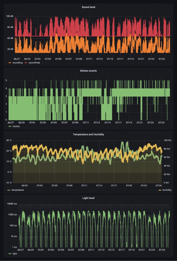
IoT allows for the deployment of low-power, low-cost sensors that provide an unparalleled access to real-time data from the ground. Our challenge was to manipulate this technical data to transform it into actionable insights for both visitors and destination managers alike.
With IoT being an emerging technology, it was decided that the creation of a minimal viable product (MVP) would be best, in order to test and measure our assumptions to mitigate risk. In addition to this, we partnered with one of the country’s leading IoT providers Sensational Systems to provide hardware and software expertise on IoT. The combination of tourism technology from Whereverly and IoT specialism from Sensational Systems led to the development of an innovative IoT solution, specifically designed for the needs of rural tourism.
Working with local authorities, we created the concept of ‘tourism hubs’, which represent popular locations that either directly suffer or are situated near sites that suffer from overtourism. A network of IoT sensors was deployed throughout these hubs to provide data on how busy they are.
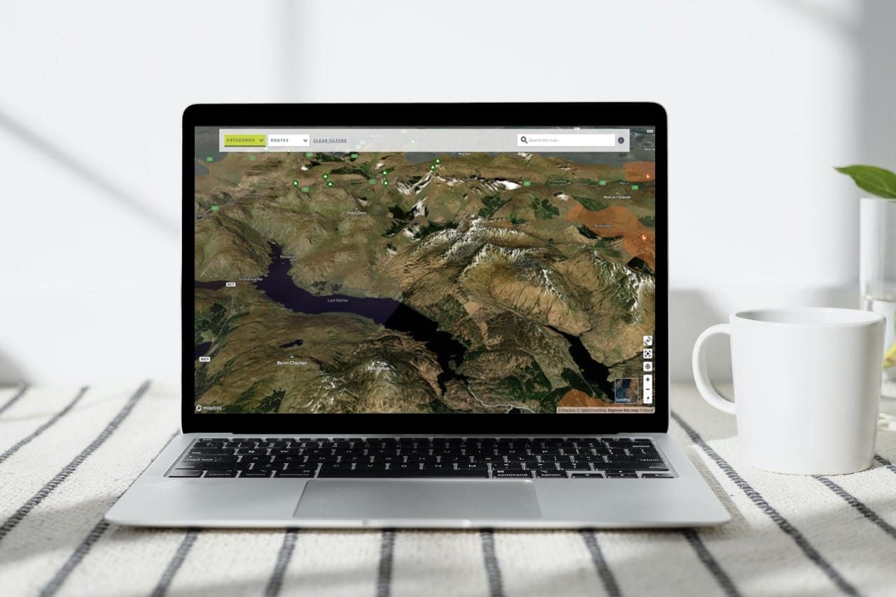
From the sensor data collected, a web map displaying the real-time busyness of a hub in LLNTP was created. The map, designed with visitors in mind, also contained key information of the area, including walking and cycling routes, wildlife hotspots and camping facilities.
Outcome
In January of 2022, we presented our MVP at the CivTech 6 Demo Day. It was hailed a great success. As such, a fully-fledged outdoors map is now being created, in collaboration with LLTNP, Stirling Council and Perth & Kinross council. The project’s reach has been extended, with a wider sensor network due to be deployed in the summer of 2022 across the National Park, as well as the Perth & Kinross area.
With the IoT data collected, the project aims to create a resource that provides both visitors and destination managers with the information needed to make informed decisions, so we can continue to enjoy a booming visitor economy, but more evenly spread.
* Civtech is a Scottish Government-run accelerator for digital public services. Launched in 2016, the accelerator runs projects aimed at injecting innovation into how the public services use technology to improve the lives of Scotland’s citizens.
For more information about CivTech, click here.

The work that Whereverly is doing is a great example of the innovation flowing from Scotland’s thriving traveltech sector, perhaps best known for success stories such as Skyscanner.
By combining data from sensors with human input from workers on the ground, and applying an algorithm, we could see an end to the kind of overtourism that has given Scotland a real headache in recent years.
Additional Information
Following on from our successful MVP over the next 12 months, we are deploying more sensors across the different council areas. Along with on-the-ground observations added by countryside rangers, this year's sensor data will be used to train an algorithm so that in future crowded areas and times can be predicted, with visitors offered alternative suggestions for places to go. These nudges will be communicated to visitors via the app, automated social media feed and variable message road signs.